


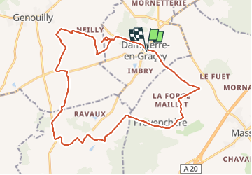
dampiere en graçais

lecmic
User

Length
21 km

Max alt
171 m

Uphill gradient
174 m
Km-Effort
24 km

Min alt
133 m

Downhill gradient
175 m
Boucle
Yes
Creation date :
2021-12-12 06:33:45.623
Updated on :
2021-12-12 10:21:22.166
3h42
Difficulty : Easy

FREE GPS app for hiking
 SityTrail
IGN / Geographical institutes
SityTrail Plus
The world is yours!
About
Trail Walking of 21 km to be discovered at Centre-Loire Valley, Cher, Dampierre-en-Graçay. This trail is proposed by lecmic.
Description
rando de noël
Positioning
Country:
France
Region :
Centre-Loire Valley
Department/Province :
Cher
Municipality :
Dampierre-en-Graçay
Location:
Unknown
Start:(Dec)
Start:(UTM)
419979 ; 5225666 (31T) N.
Comments