


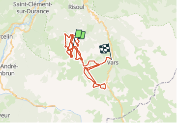
VARS

jm-barlier@sfr.fr
User

Length
50 km

Max alt
2568 m

Uphill gradient
4673 m
Km-Effort
113 km

Min alt
1635 m

Downhill gradient
5062 m
Boucle
No
Creation date :
2021-12-13 11:54:40.095
Updated on :
2021-12-14 09:30:30.447
2h54
Difficulty : Very easy

FREE GPS app for hiking
 SityTrail
IGN / Geographical institutes
SityTrail Plus
The world is yours!
About
Trail Alpine skiing of 50 km to be discovered at Provence-Alpes-Côte d'Azur, Hautes-Alpes, Risoul. This trail is proposed by jm-barlier@sfr.fr .
Positioning
Country:
France
Region :
Provence-Alpes-Côte d'Azur
Department/Province :
Hautes-Alpes
Municipality :
Risoul
Location:
Unknown
Start:(Dec)
Start:(UTM)
312332 ; 4942379 (32T) N.
Comments