Trail Walking Le Pradet - Le Pradet  la Colle noire - Photo

Le Pradet la Colle noire

 chrifor
chrifor

User

© OpenStreetMap contributors
Length
Length
5.8 km
Max alt
Max alt
111 m
Uphill gradient
Uphill gradient
154 m
Km-Effort
Km-Effort  
7.8 km
Min alt
Min alt
2 m
Downhill gradient
Downhill gradient
153 m
Boucle
Boucle
Yes
Creation date :
2021-12-15 12:09:20.268
Updated on :
2022-01-07 09:51:30.342

(0 Reviews)

Walking
Walking
1h56
Difficulty : Medium

Scan this QR Code to open this trail in the SityTrail application

FREE GPS app for hiking

Logo SityTrail SityTrail

IGN / Geographical institutes

Download SityTrail from the App Store Download SityTrail from Google Play

Logo SityTrail SityTrail Plus

The world is yours!

Download SityTrail from the App Store Download SityTrail from Google Play Download SityTrail on Huawei AppGallery

About

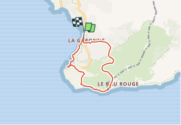
Trail Walking of 5.8 km to be discovered at Provence-Alpes-Côte d'Azur, Var, Le Pradet. This trail is proposed by chrifor.

Description

Petite randonnée-plaisir avec vue superbe: la rade de Toulon, la presqu'île de Giens et ses tombolos, les îles d'or, le fort de Brégançon...Visite possible de l'ancienne mine de cuivre...
On ne s'en lasse pas!

Elevation profile

Positioning

Country:
France
Region :
Provence-Alpes-Côte d'Azur
Department/Province :
Var
Municipality :
Le Pradet
Location:
Unknown
Start:(UTM)
257850 ; 4775288 (32T) N.


Close
My subscriptions