


Estagnous - El Fornet (Open Map)

ARVIEU
User
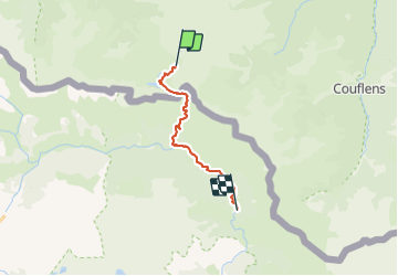

Length
13.9 km

Max alt
2526 m

Uphill gradient
622 m
Km-Effort
25 km

Min alt
1393 m

Downhill gradient
1463 m
Boucle
No
Creation date :
2021-12-15 14:15:35.914
Updated on :
2021-12-15 14:16:14.748
5h40
Difficulty : Difficult

FREE GPS app for hiking
 SityTrail
IGN / Geographical institutes
SityTrail Plus
The world is yours!
About
Trail Walking of 13.9 km to be discovered at Occitania, Ariège, Bordes-Uchentein. This trail is proposed by ARVIEU.
Positioning
Country:
France
Region :
Occitania
Department/Province :
Ariège
Municipality :
Bordes-Uchentein
Location:
Les Bordes-sur-Lez
Start:(Dec)
Start:(UTM)
342382 ; 4740103 (31T) N.
Comments