


argnat amil

Papou63patrick
User
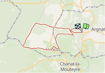

Length
8 km

Max alt
857 m

Uphill gradient
197 m
Km-Effort
10.6 km

Min alt
665 m

Downhill gradient
196 m
Boucle
Yes
Creation date :
2021-12-15 12:53:11.942
Updated on :
2021-12-15 15:32:21.539
2h09
Difficulty : Easy

FREE GPS app for hiking
 SityTrail
IGN / Geographical institutes
SityTrail Plus
The world is yours!
About
Trail Walking of 8 km to be discovered at Auvergne-Rhône-Alpes, Puy-de-Dôme, Sayat. This trail is proposed by Papou63patrick.
Positioning
Country:
France
Region :
Auvergne-Rhône-Alpes
Department/Province :
Puy-de-Dôme
Municipality :
Sayat
Location:
Unknown
Start:(Dec)
Start:(UTM)
501724 ; 5076724 (31T) N.
Comments