


VLT 1026 - Radar de Giens

jmheydorff
User
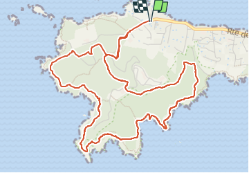

Length
7.3 km

Max alt
98 m

Uphill gradient
262 m
Km-Effort
10.8 km

Min alt
9 m

Downhill gradient
263 m
Boucle
Yes
Creation date :
2021-12-15 07:53:48.153
Updated on :
2022-12-05 10:43:25.236
2h35
Difficulty : Very difficult

FREE GPS app for hiking
 SityTrail
IGN / Geographical institutes
SityTrail Plus
The world is yours!
About
Trail Walking of 7.3 km to be discovered at Provence-Alpes-Côte d'Azur, Var, Hyères. This trail is proposed by jmheydorff.
Positioning
Country:
France
Region :
Provence-Alpes-Côte d'Azur
Department/Province :
Var
Municipality :
Hyères
Location:
Unknown
Start:(Dec)
Start:(UTM)
264174 ; 4769345 (32T) N.
Comments