


balade en VAE circuit forêt et voie verte

gilbertdu60
User

Length
21 km

Max alt
148 m

Uphill gradient
248 m
Km-Effort
25 km

Min alt
26 m

Downhill gradient
249 m
Boucle
Yes
Creation date :
2021-12-16 10:51:40.015
Updated on :
2021-12-16 10:58:35.655
--
Difficulty : Easy

FREE GPS app for hiking
 SityTrail
IGN / Geographical institutes
SityTrail Plus
The world is yours!
About
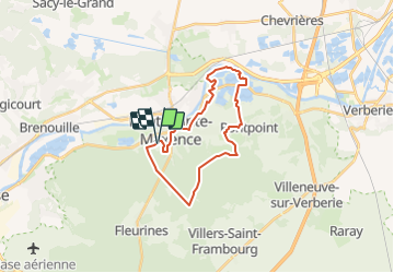
Trail Electric bike of 21 km to be discovered at Hauts-de-France, Oise, Pont-Sainte-Maxence. This trail is proposed by gilbertdu60.
Description
au départ du quartier des terriers en passant par le poteau du grand maitre, la route de la Croix Frapotel et l'église St Gervais de Pontpoint retour par la voie verte.
Positioning
Country:
France
Region :
Hauts-de-France
Department/Province :
Oise
Municipality :
Pont-Sainte-Maxence
Location:
Unknown
Start:(Dec)
Start:(UTM)
470700 ; 5460436 (31U) N.
Comments