


Col de Joux

philou6351
User
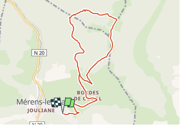

Length
11.8 km

Max alt
1768 m

Uphill gradient
714 m
Km-Effort
21 km

Min alt
1154 m

Downhill gradient
711 m
Boucle
Yes
Creation date :
2021-12-16 14:31:55.302
Updated on :
2021-12-16 14:32:32.365
4h50
Difficulty : Very difficult
--
Difficulty : Very easy

FREE GPS app for hiking
 SityTrail
IGN / Geographical institutes
SityTrail Plus
The world is yours!
About
Trail Walking of 11.8 km to be discovered at Occitania, Ariège, Mérens-les-Vals. This trail is proposed by philou6351.
Positioning
Country:
France
Region :
Occitania
Department/Province :
Ariège
Municipality :
Mérens-les-Vals
Location:
Unknown
Start:(Dec)
Start:(UTM)
405243 ; 4723227 (31T) N.
Comments