


Herbelles 12Kms (Dén P 138m)

alain62rando
User
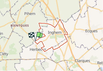

Length
12 km

Max alt
97 m

Uphill gradient
138 m
Km-Effort
13.9 km

Min alt
42 m

Downhill gradient
139 m
Boucle
Yes
Creation date :
2021-12-17 17:35:51.104
Updated on :
2021-12-17 17:37:56.454
2h50
Difficulty : Medium

FREE GPS app for hiking
 SityTrail
IGN / Geographical institutes
SityTrail Plus
The world is yours!
About
Trail Walking of 12 km to be discovered at Hauts-de-France, Pas-de-Calais, Bellinghem. This trail is proposed by alain62rando.
Description
Départ terrain de Foot
Positioning
Country:
France
Region :
Hauts-de-France
Department/Province :
Pas-de-Calais
Municipality :
Bellinghem
Location:
Unknown
Start:(Dec)
Start:(UTM)
444877 ; 5612459 (31U) N.
Comments