


Saint_Jean_de_Guargier

ARPF
User
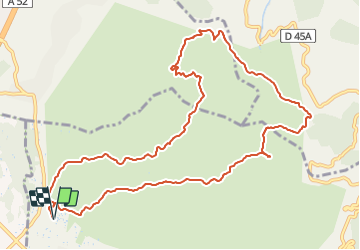

Length
13.1 km

Max alt
698 m

Uphill gradient
691 m
Km-Effort
22 km

Min alt
179 m

Downhill gradient
690 m
Boucle
Yes
Creation date :
2021-12-17 19:08:47.101
Updated on :
2021-12-17 19:09:19.698
5h04
Difficulty : Very difficult

FREE GPS app for hiking
 SityTrail
IGN / Geographical institutes
SityTrail Plus
The world is yours!
About
Trail Walking of 13.1 km to be discovered at Provence-Alpes-Côte d'Azur, Bouches-du-Rhône, Gémenos. This trail is proposed by ARPF.
Positioning
Country:
France
Region :
Provence-Alpes-Côte d'Azur
Department/Province :
Bouches-du-Rhône
Municipality :
Gémenos
Location:
Unknown
Start:(Dec)
Start:(UTM)
712044 ; 4798726 (31T) N.
Comments