


collège rognes. j.f. Marie.nicoline

NADINE52
User

Length
9.7 km

Max alt
302 m

Uphill gradient
137 m
Km-Effort
11.5 km

Min alt
240 m

Downhill gradient
135 m
Boucle
Yes
Creation date :
2021-12-21 09:29:27.105
Updated on :
2021-12-21 13:29:29.463
2h34
Difficulty : Medium

FREE GPS app for hiking
 SityTrail
IGN / Geographical institutes
SityTrail Plus
The world is yours!
About
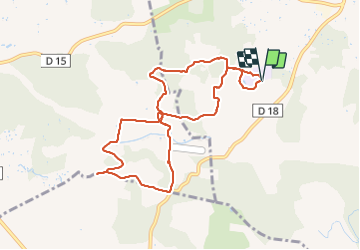
Trail Walking of 9.7 km to be discovered at Provence-Alpes-Côte d'Azur, Bouches-du-Rhône, Rognes. This trail is proposed by NADINE52.
Positioning
Country:
France
Region :
Provence-Alpes-Côte d'Azur
Department/Province :
Bouches-du-Rhône
Municipality :
Rognes
Location:
Unknown
Start:(Dec)
Start:(UTM)
687513 ; 4836011 (31T) N.
Comments