


sortie 21-12-2021

Didier-114
User

Length
7.7 km

Max alt
165 m

Uphill gradient
126 m
Km-Effort
9.4 km

Min alt
90 m

Downhill gradient
126 m
Boucle
Yes
Creation date :
2021-12-21 12:44:50.794
Updated on :
2021-12-21 15:05:43.827
2h20
Difficulty : Easy

FREE GPS app for hiking
 SityTrail
IGN / Geographical institutes
SityTrail Plus
The world is yours!
About
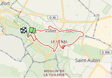
Trail Walking of 7.7 km to be discovered at Ile-de-France, Yvelines, Châteaufort. This trail is proposed by Didier-114.
Positioning
Country:
France
Region :
Ile-de-France
Department/Province :
Yvelines
Municipality :
Châteaufort
Location:
Unknown
Start:(Dec)
Start:(UTM)
434369 ; 5397109 (31U) N.
Comments