


2021 12 21 Scy HS 8 km

bstebe
User
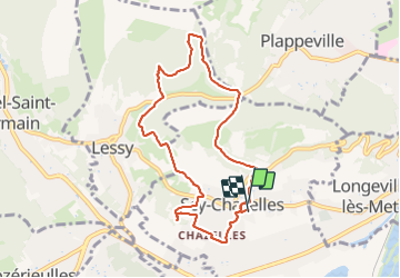

Length
8 km

Max alt
342 m

Uphill gradient
195 m
Km-Effort
10.6 km

Min alt
212 m

Downhill gradient
198 m
Boucle
Yes
Creation date :
2021-12-21 12:53:51.557
Updated on :
2021-12-21 15:46:12.875
2h51
Difficulty : Medium

FREE GPS app for hiking
 SityTrail
IGN / Geographical institutes
SityTrail Plus
The world is yours!
About
Trail Walking of 8 km to be discovered at Grand Est, Moselle, Scy-Chazelles. This trail is proposed by bstebe.
Positioning
Country:
France
Region :
Grand Est
Department/Province :
Moselle
Municipality :
Scy-Chazelles
Location:
Unknown
Start:(Dec)
Start:(UTM)
289608 ; 5444180 (32U) N.
Comments