


couraduque

harydh
User GUIDE
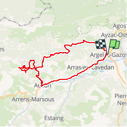

Length
35 km

Max alt
1549 m

Uphill gradient
1197 m
Km-Effort
51 km

Min alt
480 m

Downhill gradient
1197 m
Boucle
Yes
Creation date :
2014-12-10 00:00:00.0
Updated on :
2014-12-10 00:00:00.0
3h19
Difficulty : Difficult

FREE GPS app for hiking
 SityTrail
IGN / Geographical institutes
SityTrail Plus
The world is yours!
About
Trail Mountain bike of 35 km to be discovered at Occitania, Hautespyrenees, Argelès-Gazost. This trail is proposed by harydh.
Positioning
Country:
France
Region :
Occitania
Department/Province :
Hautespyrenees
Municipality :
Argelès-Gazost
Location:
Unknown
Start:(Dec)
Start:(UTM)
736107 ; 4765371 (30T) N.
Comments