


Sospel - St Agnès2

ARPF
User
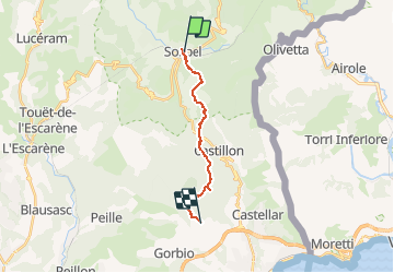

Length
14.3 km

Max alt
850 m

Uphill gradient
936 m
Km-Effort
26 km

Min alt
345 m

Downhill gradient
611 m
Boucle
No
Creation date :
2014-12-10 00:00:00.0
Updated on :
2014-12-10 00:00:00.0
5h54
Difficulty : Medium

FREE GPS app for hiking
 SityTrail
IGN / Geographical institutes
SityTrail Plus
The world is yours!
About
Trail Walking of 14.3 km to be discovered at Provence-Alpes-Côte d'Azur, Maritime Alps, Sospel. This trail is proposed by ARPF.
Description
Trace de Jacques S 2014
Positioning
Country:
France
Region :
Provence-Alpes-Côte d'Azur
Department/Province :
Maritime Alps
Municipality :
Sospel
Location:
Unknown
Start:(Dec)
Start:(UTM)
375541 ; 4859507 (32T) N.
Comments