


dassy entre deux

funkady
User
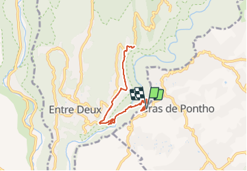

Length
12.2 km

Max alt
680 m

Uphill gradient
764 m
Km-Effort
22 km

Min alt
233 m

Downhill gradient
765 m
Boucle
Yes
Creation date :
2021-12-23 08:57:09.505
Updated on :
2021-12-23 08:58:52.485
2h00
Difficulty : Medium

FREE GPS app for hiking
 SityTrail
IGN / Geographical institutes
SityTrail Plus
The world is yours!
About
Trail Trail of 12.2 km to be discovered at Réunion, Unknown, Le Tampon. This trail is proposed by funkady.
Positioning
Country:
France
Region :
Réunion
Department/Province :
Unknown
Municipality :
Le Tampon
Location:
Unknown
Start:(Dec)
Start:(UTM)
343126 ; 7649589 (40K) S.
Comments