


Etretat porte d'Aval

geoffrayLayeux
User
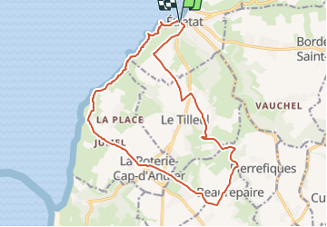

Length
16.6 km

Max alt
115 m

Uphill gradient
356 m
Km-Effort
21 km

Min alt
4 m

Downhill gradient
357 m
Boucle
Yes
Creation date :
2021-12-25 14:06:07.223
Updated on :
2021-12-25 14:06:46.114
4h50
Difficulty : Very difficult

FREE GPS app for hiking
 SityTrail
IGN / Geographical institutes
SityTrail Plus
The world is yours!
About
Trail Walking of 16.6 km to be discovered at Normandy, Seine-Maritime, Étretat. This trail is proposed by geoffrayLayeux.
Positioning
Country:
France
Region :
Normandy
Department/Province :
Seine-Maritime
Municipality :
Étretat
Location:
Unknown
Start:(Dec)
Start:(UTM)
298219 ; 5509854 (31U) N.
Comments