


Didier

azipat
User
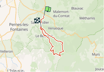

Length
25 km

Max alt
663 m

Uphill gradient
621 m
Km-Effort
33 km

Min alt
139 m

Downhill gradient
587 m
Boucle
No
Creation date :
2021-12-28 21:34:40.175
Updated on :
2021-12-28 21:34:47.75
10h00
Difficulty : Very easy

FREE GPS app for hiking
 SityTrail
IGN / Geographical institutes
SityTrail Plus
The world is yours!
About
Trail Coupling of 25 km to be discovered at Provence-Alpes-Côte d'Azur, Vaucluse, Venasque. This trail is proposed by azipat.
Positioning
Country:
France
Region :
Provence-Alpes-Côte d'Azur
Department/Province :
Vaucluse
Municipality :
Venasque
Location:
Unknown
Start:(Dec)
Start:(UTM)
669846 ; 4876037 (31T) N.
Comments