


st nectaire

aldaus
User
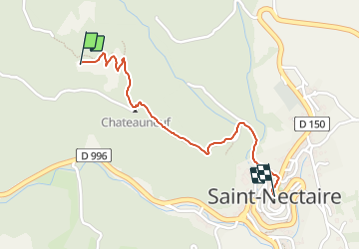

Length
1.3 km

Max alt
879 m

Uphill gradient
9 m
Km-Effort
1.9 km

Min alt
728 m

Downhill gradient
145 m
Boucle
No
Creation date :
2021-12-29 14:41:55.322
Updated on :
2021-12-29 15:12:24.344
29m
Difficulty : Very easy

FREE GPS app for hiking
 SityTrail
IGN / Geographical institutes
SityTrail Plus
The world is yours!
About
Trail Walking of 1.3 km to be discovered at Auvergne-Rhône-Alpes, Puy-de-Dôme, Saint-Nectaire. This trail is proposed by aldaus.
Positioning
Country:
France
Region :
Auvergne-Rhône-Alpes
Department/Province :
Puy-de-Dôme
Municipality :
Saint-Nectaire
Location:
Unknown
Start:(Dec)
Start:(UTM)
498763 ; 5048771 (31T) N.
Comments