


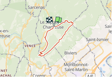
depart le sappey en chartreuse

gerardmicheline
User

Length
10.6 km

Max alt
1372 m

Uphill gradient
578 m
Km-Effort
18.3 km

Min alt
960 m

Downhill gradient
587 m
Boucle
Yes
Creation date :
2021-12-29 16:51:53.372
Updated on :
2021-12-29 16:53:04.811
4h09
Difficulty : Difficult

FREE GPS app for hiking
 SityTrail
IGN / Geographical institutes
SityTrail Plus
The world is yours!
About
Trail Walking of 10.6 km to be discovered at Auvergne-Rhône-Alpes, Isère, Le Sappey-en-Chartreuse. This trail is proposed by gerardmicheline.
Positioning
Country:
France
Region :
Auvergne-Rhône-Alpes
Department/Province :
Isère
Municipality :
Le Sappey-en-Chartreuse
Location:
Unknown
Start:(Dec)
Start:(UTM)
718007 ; 5015399 (31T) N.
Comments