BOUZIES SAINT CIRQ LAPOPIE

PascalBanide
User
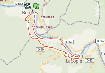

Length
9 km

Max alt
280 m

Uphill gradient
369 m
Km-Effort
13.9 km

Min alt
129 m

Downhill gradient
366 m
Boucle
Yes
Creation date :
2021-12-30 12:15:14.0
Updated on :
2021-12-30 14:54:42.602
2h38
Difficulty : Difficult

FREE GPS app for hiking
 SityTrail
IGN / Geographical institutes
SityTrail Plus
The world is yours!
About
Trail Walking of 9 km to be discovered at Occitania, Lot, Bouziès. This trail is proposed by PascalBanide.
Positioning
Country:
France
Region :
Occitania
Department/Province :
Lot
Municipality :
Bouziès
Location:
Unknown
Start:(Dec)
Start:(UTM)
392191 ; 4926522 (31T) N.
Comments