


Ruisseau du Roi ( variante )

Fky78
User
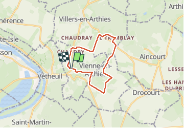

Length
10.3 km

Max alt
181 m

Uphill gradient
216 m
Km-Effort
13.2 km

Min alt
47 m

Downhill gradient
215 m
Boucle
Yes
Creation date :
2021-12-31 11:37:40.928
Updated on :
2023-05-15 16:13:25.774
3h00
Difficulty : Medium

FREE GPS app for hiking
 SityTrail
IGN / Geographical institutes
SityTrail Plus
The world is yours!
About
Trail Walking of 10.3 km to be discovered at Ile-de-France, Val-d'Oise, Vienne-en-Arthies. This trail is proposed by Fky78.
Positioning
Country:
France
Region :
Ile-de-France
Department/Province :
Val-d'Oise
Municipality :
Vienne-en-Arthies
Location:
Unknown
Start:(Dec)
Start:(UTM)
406322 ; 5435653 (31U) N.
Comments