


rocher de miglos

lablaquiere
User
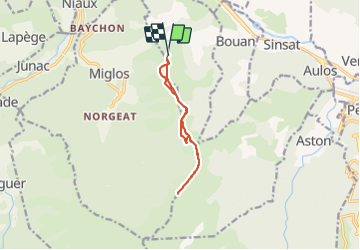

Length
10 km

Max alt
1686 m

Uphill gradient
506 m
Km-Effort
16.8 km

Min alt
1191 m

Downhill gradient
507 m
Boucle
Yes
Creation date :
2022-01-01 10:31:28.446
Updated on :
2022-01-01 16:02:24.125
3h05
Difficulty : Difficult

FREE GPS app for hiking
 SityTrail
IGN / Geographical institutes
SityTrail Plus
The world is yours!
About
Trail Walking of 10 km to be discovered at Occitania, Ariège, Larnat. This trail is proposed by lablaquiere.
Positioning
Country:
France
Region :
Occitania
Department/Province :
Ariège
Municipality :
Larnat
Location:
Unknown
Start:(Dec)
Start:(UTM)
387280 ; 4739055 (31T) N.
Comments