


bories.loriol . cimetière

NADINE52
User
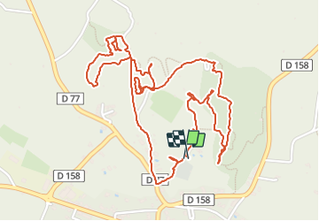

Length
4 km

Max alt
265 m

Uphill gradient
80 m
Km-Effort
5 km

Min alt
205 m

Downhill gradient
74 m
Boucle
Yes
Creation date :
2022-01-02 09:29:44.47
Updated on :
2022-01-02 12:18:03.637
1h22
Difficulty : Easy

FREE GPS app for hiking
 SityTrail
IGN / Geographical institutes
SityTrail Plus
The world is yours!
About
Trail Walking of 4 km to be discovered at Provence-Alpes-Côte d'Azur, Vaucluse, Malemort-du-Comtat. This trail is proposed by NADINE52.
Positioning
Country:
France
Region :
Provence-Alpes-Côte d'Azur
Department/Province :
Vaucluse
Municipality :
Malemort-du-Comtat
Location:
Unknown
Start:(Dec)
Start:(UTM)
673082 ; 4876836 (31T) N.
Comments