


2022-01-02 Fort Louis

Bernardb44
User
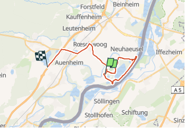

Length
21 km

Max alt
129 m

Uphill gradient
137 m
Km-Effort
22 km

Min alt
111 m

Downhill gradient
138 m
Boucle
No
Creation date :
2022-01-02 10:28:51.222
Updated on :
2022-01-02 14:32:29.388
4h02
Difficulty : Very easy

FREE GPS app for hiking
 SityTrail
IGN / Geographical institutes
SityTrail Plus
The world is yours!
About
Trail Walking of 21 km to be discovered at Grand Est, Bas-Rhin, Fort-Louis. This trail is proposed by Bernardb44.
Positioning
Country:
France
Region :
Grand Est
Department/Province :
Bas-Rhin
Municipality :
Fort-Louis
Location:
Unknown
Start:(Dec)
Start:(UTM)
430682 ; 5405758 (32U) N.
Comments