


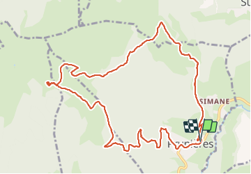
Le Serre du Chat Pendu en circuit

Emelle
User

Length
12.9 km

Max alt
1457 m

Uphill gradient
654 m
Km-Effort
22 km

Min alt
851 m

Downhill gradient
655 m
Boucle
Yes
Creation date :
2022-01-02 08:46:33.187
Updated on :
2022-01-02 15:07:25.505
5h26
Difficulty : Medium

FREE GPS app for hiking
 SityTrail
IGN / Geographical institutes
SityTrail Plus
The world is yours!
About
Trail Walking of 12.9 km to be discovered at Auvergne-Rhône-Alpes, Isère, Prunières. This trail is proposed by Emelle.
Positioning
Country:
France
Region :
Auvergne-Rhône-Alpes
Department/Province :
Isère
Municipality :
Prunières
Location:
Unknown
Start:(Dec)
Start:(UTM)
718484 ; 4974857 (31T) N.
Comments