


roche d'Oetre

geoffrayLayeux
User
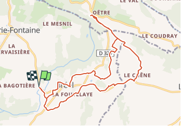

Length
10.8 km

Max alt
241 m

Uphill gradient
238 m
Km-Effort
13.9 km

Min alt
99 m

Downhill gradient
239 m
Boucle
Yes
Creation date :
2022-01-02 18:52:22.583
Updated on :
2022-01-02 18:52:25.839
3h10
Difficulty : Difficult

FREE GPS app for hiking
 SityTrail
IGN / Geographical institutes
SityTrail Plus
The world is yours!
About
Trail Walking of 10.8 km to be discovered at Normandy, Orne, Athis-Val-de-Rouvre. This trail is proposed by geoffrayLayeux.
Positioning
Country:
France
Region :
Normandy
Department/Province :
Orne
Municipality :
Athis-Val-de-Rouvre
Location:
Ségrie-Fontaine
Start:(Dec)
Start:(UTM)
690974 ; 5409862 (30U) N.
Comments