


les enfrux 11kms

francoiseremy
User
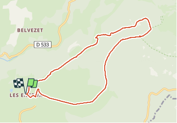

Length
11.5 km

Max alt
1332 m

Uphill gradient
272 m
Km-Effort
15.2 km

Min alt
1110 m

Downhill gradient
272 m
Boucle
Yes
Creation date :
2022-01-03 18:18:43.169
Updated on :
2022-01-03 18:19:21.968

FREE GPS app for hiking
 SityTrail
IGN / Geographical institutes
SityTrail Plus
The world is yours!
About
Trail of 11.5 km to be discovered at Occitania, Aveyron, Saint-Chély-d'Aubrac. This trail is proposed by francoiseremy.
Positioning
Country:
France
Region :
Occitania
Department/Province :
Aveyron
Municipality :
Saint-Chély-d'Aubrac
Location:
Unknown
Start:(Dec)
Start:(UTM)
496118 ; 4936904 (31T) N.
Comments