


Tour du Queyras - Etape 2

CLP01
User
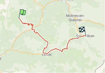

Length
29 km

Max alt
2648 m

Uphill gradient
2226 m
Km-Effort
60 km

Min alt
1188 m

Downhill gradient
2504 m
Boucle
No
Creation date :
2022-01-03 19:07:11.46
Updated on :
2022-01-03 19:08:04.507
13h33
Difficulty : Very difficult

FREE GPS app for hiking
 SityTrail
IGN / Geographical institutes
SityTrail Plus
The world is yours!
About
Trail Walking of 29 km to be discovered at Provence-Alpes-Côte d'Azur, Hautes-Alpes, Arvieux. This trail is proposed by CLP01.
Description
2230D /29Km
Positioning
Country:
France
Region :
Provence-Alpes-Côte d'Azur
Department/Province :
Hautes-Alpes
Municipality :
Arvieux
Location:
Unknown
Start:(Dec)
Start:(UTM)
318839 ; 4955259 (32T) N.
Comments