


Tour du Queyras - Etape 3

CLP01
User
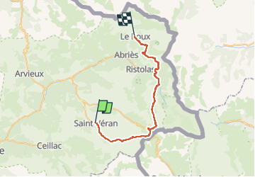

Length
36 km

Max alt
2880 m

Uphill gradient
2151 m
Km-Effort
66 km

Min alt
1662 m

Downhill gradient
2423 m
Boucle
No
Creation date :
2022-01-03 20:24:48.347
Updated on :
2022-07-03 17:28:50.731
12h13
Difficulty : Very difficult

FREE GPS app for hiking
 SityTrail
IGN / Geographical institutes
SityTrail Plus
The world is yours!
About
Trail Walking of 36 km to be discovered at Provence-Alpes-Côte d'Azur, Hautes-Alpes, Saint-Véran. This trail is proposed by CLP01.
Description
Avec variante pour raccourcir
1500D /32Km
Positioning
Country:
France
Region :
Provence-Alpes-Côte d'Azur
Department/Province :
Hautes-Alpes
Municipality :
Saint-Véran
Location:
Unknown
Start:(Dec)
Start:(UTM)
331090 ; 4951897 (32T) N.
Comments