


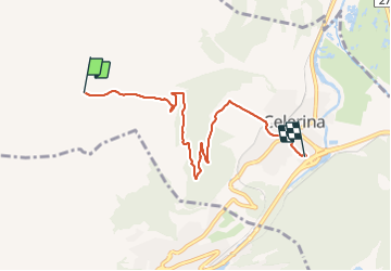
Marguns Celerina

šarūnas
User

Length
5.8 km

Max alt
2265 m

Uphill gradient
14 m
Km-Effort
7.8 km

Min alt
1716 m

Downhill gradient
560 m
Boucle
No
Creation date :
2022-01-04 11:23:59.0
Updated on :
2022-01-04 12:48:23.397
1h24
Difficulty : Medium

FREE GPS app for hiking
 SityTrail
IGN / Geographical institutes
SityTrail Plus
The world is yours!
About
Trail Walking of 5.8 km to be discovered at Grisons, Maloja, Celerina/Schlarigna. This trail is proposed by šarūnas.
Positioning
Country:
Switzerland
Region :
Grisons
Department/Province :
Maloja
Municipality :
Celerina/Schlarigna
Location:
Unknown
Start:(Dec)
Start:(UTM)
563318 ; 5151755 (32T) N.
Comments