


D32 - GR 10

loic09
User
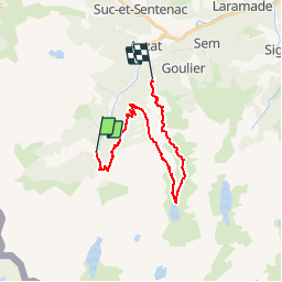

Length
22 km

Max alt
1777 m

Uphill gradient
1537 m
Km-Effort
41 km

Min alt
1009 m

Downhill gradient
1131 m
Boucle
No
Creation date :
2014-12-10 00:00:00.0
Updated on :
2014-12-10 00:00:00.0
8h58
Difficulty : Medium

FREE GPS app for hiking
 SityTrail
IGN / Geographical institutes
SityTrail Plus
The world is yours!
About
Trail Walking of 22 km to be discovered at Occitania, Ariège, Auzat. This trail is proposed by loic09.
Description
Marc/Stèle GR10

Positioning
Country:
France
Region :
Occitania
Department/Province :
Ariège
Municipality :
Auzat
Location:
Unknown
Start:(Dec)
Start:(UTM)
373006 ; 4730513 (31T) N.
Comments