


balade hivernale

erisel
User
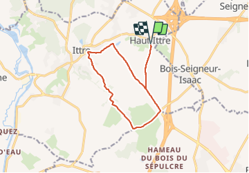

Length
12 km

Max alt
153 m

Uphill gradient
183 m
Km-Effort
14.4 km

Min alt
75 m

Downhill gradient
183 m
Boucle
Yes
Creation date :
2022-01-05 09:58:14.458
Updated on :
2022-01-05 13:27:38.476
3h28
Difficulty : Easy

FREE GPS app for hiking
 SityTrail
IGN / Geographical institutes
SityTrail Plus
The world is yours!
About
Trail Walking of 12 km to be discovered at Wallonia, Walloon Brabant, Ittre. This trail is proposed by erisel.
Positioning
Country:
Belgium
Region :
Wallonia
Department/Province :
Walloon Brabant
Municipality :
Ittre
Location:
Unknown
Start:(Dec)
Start:(UTM)
591770 ; 5611932 (31U) N.
Comments