


givry

mcterret
User
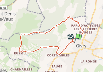

Length
9.1 km

Max alt
434 m

Uphill gradient
243 m
Km-Effort
12.3 km

Min alt
226 m

Downhill gradient
243 m
Boucle
Yes
Creation date :
2022-01-05 12:59:46.513
Updated on :
2022-01-05 15:25:53.17
2h08
Difficulty : Easy

FREE GPS app for hiking
 SityTrail
IGN / Geographical institutes
SityTrail Plus
The world is yours!
About
Trail Walking of 9.1 km to be discovered at Bourgogne-Franche-Comté, Saône-et-Loire, Givry. This trail is proposed by mcterret.
Positioning
Country:
France
Region :
Bourgogne-Franche-Comté
Department/Province :
Saône-et-Loire
Municipality :
Givry
Location:
Unknown
Start:(Dec)
Start:(UTM)
632760 ; 5182641 (31T) N.
Comments