


croix valmer - Oppidum de Monjean

soca
User
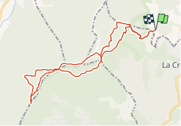

Length
12.6 km

Max alt
453 m

Uphill gradient
476 m
Km-Effort
19 km

Min alt
88 m

Downhill gradient
476 m
Boucle
Yes
Creation date :
2021-12-02 08:55:20.592
Updated on :
2022-01-05 16:40:57.748
4h54
Difficulty : Medium

FREE GPS app for hiking
 SityTrail
IGN / Geographical institutes
SityTrail Plus
The world is yours!
About
Trail Walking of 12.6 km to be discovered at Provence-Alpes-Côte d'Azur, Var, Gassin. This trail is proposed by soca.
Positioning
Country:
France
Region :
Provence-Alpes-Côte d'Azur
Department/Province :
Var
Municipality :
Gassin
Location:
Unknown
Start:(Dec)
Start:(UTM)
301493 ; 4787778 (32T) N.
Comments