


St Pierre Lapalud - Chevinay

daniellebou
User
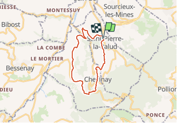

Length
11.3 km

Max alt
599 m

Uphill gradient
413 m
Km-Effort
16.8 km

Min alt
300 m

Downhill gradient
416 m
Boucle
Yes
Creation date :
2022-01-06 08:04:52.418
Updated on :
2022-01-06 11:13:48.022
3h08
Difficulty : Difficult

FREE GPS app for hiking
 SityTrail
IGN / Geographical institutes
SityTrail Plus
The world is yours!
About
Trail Walking of 11.3 km to be discovered at Auvergne-Rhône-Alpes, Rhône, Saint-Pierre-la-Palud. This trail is proposed by daniellebou.
Positioning
Country:
France
Region :
Auvergne-Rhône-Alpes
Department/Province :
Rhône
Municipality :
Saint-Pierre-la-Palud
Location:
Unknown
Start:(Dec)
Start:(UTM)
625284 ; 5072066 (31T) N.
Comments