Trail Walking Roquebrune-sur-Argens - 
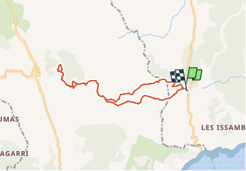
Le Peigros depuis le Bougnon - Photo
 ETMU5496
ETMU5496

User

© OpenStreetMap contributors
Length
Length
16.2 km
Max alt
Max alt
524 m
Uphill gradient
Uphill gradient
679 m
Km-Effort
Km-Effort  
25 km
Min alt
Min alt
122 m
Downhill gradient
Downhill gradient
695 m
Boucle
Boucle
Yes
Creation date :
2022-01-06 07:59:14.0
Updated on :
2022-01-07 14:31:38.893

(0 Reviews)

Walking
Walking
3h58
Difficulty : Medium

Scan this QR Code to open this trail in the SityTrail application

FREE GPS app for hiking

Logo SityTrail SityTrail

IGN / Geographical institutes

Download SityTrail from the App Store Download SityTrail from Google Play

Logo SityTrail SityTrail Plus

The world is yours!

Download SityTrail from the App Store Download SityTrail from Google Play Download SityTrail on Huawei AppGallery

About

Trail Walking of 16.2 km to be discovered at Provence-Alpes-Côte d'Azur, Var, Roquebrune-sur-Argens. This trail is proposed by ETMU5496.

Description

Randonnée un peu vallonnée au départ avec quelques raidillons à franchir. Belles pistes ensuite jusqu'au Peigros.
A noter : Le tour du Peigros emprunte sur un passage en pente accentué un sentier peu marqué.

Elevation profile

Photos

Positioning

Country:
France
Region :
Provence-Alpes-Côte d'Azur
Department/Province :
Var
Municipality :
Roquebrune-sur-Argens
Location:
Unknown
Start:(UTM)
311365 ; 4803876 (32T) N.


Close
My subscriptions