


Sanguinettes 6 janvier 2021

rlebasque
User
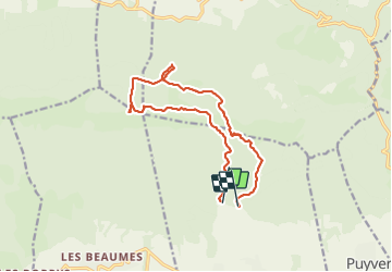

Length
14.4 km

Max alt
723 m

Uphill gradient
484 m
Km-Effort
21 km

Min alt
251 m

Downhill gradient
505 m
Boucle
No
Creation date :
2022-01-06 08:10:43.04
Updated on :
2022-01-06 14:06:29.293
5h54
Difficulty : Very difficult

FREE GPS app for hiking
 SityTrail
IGN / Geographical institutes
SityTrail Plus
The world is yours!
About
Trail Walking of 14.4 km to be discovered at Provence-Alpes-Côte d'Azur, Vaucluse, Lauris. This trail is proposed by rlebasque.
Positioning
Country:
France
Region :
Provence-Alpes-Côte d'Azur
Department/Province :
Vaucluse
Municipality :
Lauris
Location:
Unknown
Start:(Dec)
Start:(UTM)
684743 ; 4849212 (31T) N.
Comments