


grand rocher

Liebeaux
User
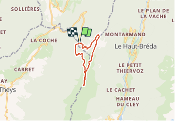

Length
10.1 km

Max alt
1915 m

Uphill gradient
502 m
Km-Effort
16.8 km

Min alt
1426 m

Downhill gradient
508 m
Boucle
Yes
Creation date :
2022-01-06 08:31:51.556
Updated on :
2022-01-06 16:35:53.676
4h57
Difficulty : Difficult

FREE GPS app for hiking
 SityTrail
IGN / Geographical institutes
SityTrail Plus
The world is yours!
About
Trail Walking of 10.1 km to be discovered at Auvergne-Rhône-Alpes, Isère, Crêts-en-Belledonne. This trail is proposed by Liebeaux.
Positioning
Country:
France
Region :
Auvergne-Rhône-Alpes
Department/Province :
Isère
Municipality :
Crêts-en-Belledonne
Location:
Saint-Pierre-d'Allevard
Start:(Dec)
Start:(UTM)
268587 ; 5023269 (32T) N.
Comments