


thuin dreve des allies 1241

andre.rochet.ar
User
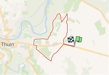

Length
7 km

Max alt
209 m

Uphill gradient
47 m
Km-Effort
7.7 km

Min alt
185 m

Downhill gradient
48 m
Boucle
Yes
Creation date :
2022-01-07 11:41:33.897
Updated on :
2024-01-26 14:57:50.875
--
Difficulty : Very easy

FREE GPS app for hiking
 SityTrail
IGN / Geographical institutes
SityTrail Plus
The world is yours!
About
Trail Nordic walking of 7 km to be discovered at Wallonia, Hainaut, Thuin. This trail is proposed by andre.rochet.ar.
Positioning
Country:
Belgium
Region :
Wallonia
Department/Province :
Hainaut
Municipality :
Thuin
Location:
Unknown
Start:(Dec)
Start:(UTM)
594300 ; 5577181 (31U) N.
Comments
marche facile