


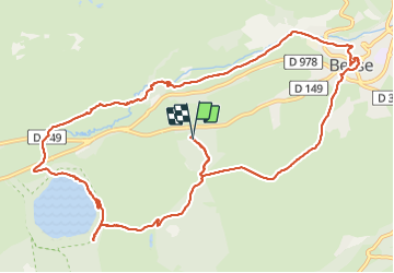
Lac pavin / Besse

zefreefly
User

Length
14 km

Max alt
1281 m

Uphill gradient
341 m
Km-Effort
18.6 km

Min alt
1014 m

Downhill gradient
337 m
Boucle
Yes
Creation date :
2022-01-07 09:53:59.0
Updated on :
2022-01-07 15:00:37.382
3h44
Difficulty : Easy

FREE GPS app for hiking
 SityTrail
IGN / Geographical institutes
SityTrail Plus
The world is yours!
About
Trail Walking of 14 km to be discovered at Auvergne-Rhône-Alpes, Puy-de-Dôme, Besse-et-Saint-Anastaise. This trail is proposed by zefreefly.
Description
Parking pertuyzat
Jolie Rand agréable sans difficultés
Positioning
Country:
France
Region :
Auvergne-Rhône-Alpes
Department/Province :
Puy-de-Dôme
Municipality :
Besse-et-Saint-Anastaise
Location:
Besse
Start:(Dec)
Start:(UTM)
492827 ; 5038907 (31T) N.
Comments