Le Latay-Les Meaulnes

francisdean
User
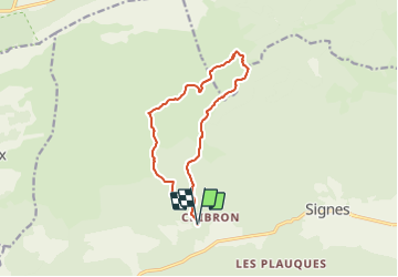

Length
12.7 km

Max alt
664 m

Uphill gradient
306 m
Km-Effort
16.8 km

Min alt
424 m

Downhill gradient
305 m
Boucle
Yes
Creation date :
2022-01-08 14:42:39.007
Updated on :
2022-01-11 18:09:29.538
3h45
Difficulty : Easy

FREE GPS app for hiking
 SityTrail
IGN / Geographical institutes
SityTrail Plus
The world is yours!
About
Trail Walking of 12.7 km to be discovered at Provence-Alpes-Côte d'Azur, Var, Signes. This trail is proposed by francisdean.
Positioning
Country:
France
Region :
Provence-Alpes-Côte d'Azur
Department/Province :
Var
Municipality :
Signes
Location:
Unknown
Start:(Dec)
Start:(UTM)
729050 ; 4796608 (31T) N.
Comments