


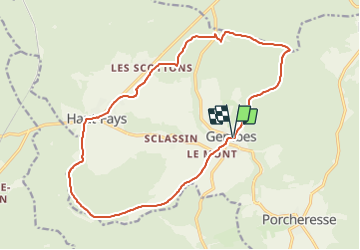
RB-PN-02C-QR3-16km6_2021-12-31

GR Rando (plus commercialisé)
Randonnez sur et autour des GR ® wallons (Sentiers de Grande Randonnée). PRO

Length
16.6 km

Max alt
438 m

Uphill gradient
293 m
Km-Effort
20 km

Min alt
263 m

Downhill gradient
289 m
Boucle
Yes
Creation date :
2022-01-08 14:58:30.543
Updated on :
2022-01-08 14:59:06.078
4h38
Difficulty : Very difficult

FREE GPS app for hiking
 SityTrail
IGN / Geographical institutes
SityTrail Plus
The world is yours!
About
Trail Walking of 16.6 km to be discovered at Wallonia, Luxembourg, Daverdisse. This trail is proposed by GR Rando (plus commercialisé).


Positioning
Country:
Belgium
Region :
Wallonia
Department/Province :
Luxembourg
Municipality :
Daverdisse
Location:
Unknown
Start:(Dec)
Start:(UTM)
647928 ; 5540334 (31U) N.
Comments