


st victor des oules accro branché église château mont aigu lavoir

Dan30
User
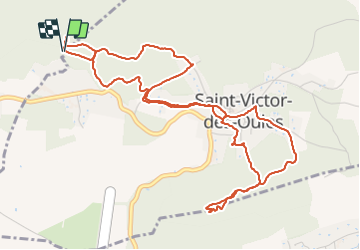

Length
6.8 km

Max alt
246 m

Uphill gradient
174 m
Km-Effort
9.1 km

Min alt
132 m

Downhill gradient
170 m
Boucle
Yes
Creation date :
2022-01-09 10:19:45.739
Updated on :
2022-01-09 11:52:06.311
1h24
Difficulty : Easy

FREE GPS app for hiking
 SityTrail
IGN / Geographical institutes
SityTrail Plus
The world is yours!
About
Trail Walking of 6.8 km to be discovered at Occitania, Gard, Saint-Quentin-la-Poterie. This trail is proposed by Dan30.
Positioning
Country:
France
Region :
Occitania
Department/Province :
Gard
Municipality :
Saint-Quentin-la-Poterie
Location:
Unknown
Start:(Dec)
Start:(UTM)
617753 ; 4877993 (31T) N.
Comments