


Chantemelle

Airelle
User
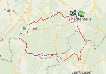

Length
19.9 km

Max alt
366 m

Uphill gradient
387 m
Km-Effort
25 km

Min alt
266 m

Downhill gradient
390 m
Boucle
Yes
Creation date :
2022-01-09 13:00:50.0
Updated on :
2022-01-09 16:33:11.103
3h31
Difficulty : Very difficult

FREE GPS app for hiking
 SityTrail
IGN / Geographical institutes
SityTrail Plus
The world is yours!
About
Trail Walking of 19.9 km to be discovered at Wallonia, Luxembourg, Étalle. This trail is proposed by Airelle.
Positioning
Country:
Belgium
Region :
Wallonia
Department/Province :
Luxembourg
Municipality :
Étalle
Location:
Chantemelle
Start:(Dec)
Start:(UTM)
691399 ; 5503353 (31U) N.
Comments