


Le tour des Amarines GR 653

Clo0413
User

Length
14 km

Max alt
668 m

Uphill gradient
458 m
Km-Effort
20 km

Min alt
470 m

Downhill gradient
462 m
Boucle
Yes
Creation date :
2022-01-10 08:44:34.098
Updated on :
2022-01-10 17:51:52.463
4h04
Difficulty : Medium

FREE GPS app for hiking
 SityTrail
IGN / Geographical institutes
SityTrail Plus
The world is yours!
About
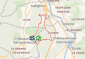
Trail Walking of 14 km to be discovered at Provence-Alpes-Côte d'Azur, Alpes-de-Haute-Provence, Châteauneuf-Val-Saint-Donat. This trail is proposed by Clo0413.
Positioning
Country:
France
Region :
Provence-Alpes-Côte d'Azur
Department/Province :
Alpes-de-Haute-Provence
Municipality :
Châteauneuf-Val-Saint-Donat
Location:
Unknown
Start:(Dec)
Start:(UTM)
737397 ; 4886148 (31T) N.
Comments