![](/images/other/stat-length.png)
![Trail Walking Héron - Promenade des châteaux (Couthuin) - Photo](https://media.geolcdn.com/t/1900/400/ext.pjpeg?maxdim=2&url=https%3A%2F%2Fmedia.geolcdn.com%2Ff%2Fd580117c-a9d5-4ac9-a44f-0f59b38e05c1.jpg)
Promenade des châteaux (Couthuin)
Au fil de nos découvertes
« L’heure de la fin des découvertes ne sonne jamais. » Colette GUIDE+
![Length](/images/other/stat-length.png)
![Max alt](https://static1.geolcdn.com/siteimages/upload/files/1508320355ic_sort_altitude_max_24dp.png)
![Uphill gradient](https://static1.geolcdn.com/siteimages/upload/files/1508320355ic_sort_den_pos_24dp.png)
![Km-Effort](/images/other/stat-length.png)
![Min alt](https://static1.geolcdn.com/siteimages/upload/files/1508320355ic_sort_altitude_min_24dp.png)
![Downhill gradient](https://static1.geolcdn.com/siteimages/upload/files/1508320355ic_sort_den_neg_24dp.png)
![Boucle](https://static1.geolcdn.com/siteimages/upload/files/16400158638029165_repeat_loop_refresh_sync_direction_icon.png)
![Walking](https://static1.geolcdn.com/sitytour/trail-icons/101.png)
2h25
Difficulty : Medium
![Scan this QR Code to open this trail in the SityTrail application](https://capi.geolives.com/qq0zvz2zws4bq2lad0pu/sitytour/trails/3047356/qr.png?size=200)
FREE GPS app for hiking
About
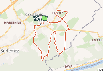
Trail Walking of 9.1 km to be discovered at Wallonia, Liège, Héron. This trail is proposed by Au fil de nos découvertes.
Description
🅿️ Départ et Parking:
Petit abri
Rue Simon
4218 Héron
Si le parking est complet, merci de vous garer : Rue Pied du Thier, non loin de la plaine. Il est évident, qu’il est important de ne pas gêner le voisinage lorsque vous vous garez.
▶️ Suivre la balise « rectangle bleu »
🌲🌳
Cette promenade au départ du petit village de Couthuin est composée de petites grimpettes.
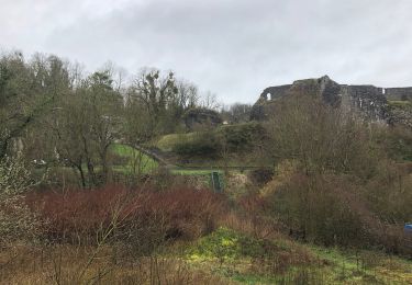
Elle vous emmènera à travers les campagnes, forêts, villages et vous fera découvrir ainsi, quelques magnifiques châteaux.
Possibilités de pique-niquer. 🥪🍴
Chiens autorisés en laisse. 🐩🐶🐕
Convient pour les enfants, plaine de jeux au départ . 👱👱♂️
Ne convient pas pour les poussettes et personnes à mobilité réduite. 👨🦽👩🦽👶
N'hésitez pas à aller faire un tour sur notre site internet et nos réseaux :
www.aufildenosdecouvertes.com
www.facebook.com/aufildenosdecouvertes
https://www.instagram.com/au_fil_de_nos_decouvertes/
Positioning
Comments
Trails nearby
![Trail Walking Andenne - RB-Na-17-Au pays de Sainte-Begge - Photo](https://media.geolcdn.com/t/375/260/ext.jpg?maxdim=2&url=https%3A%2F%2Fmedia.geolcdn.com%2Ff%2Fa98e41e8-d17a-4a0a-a324-abaf90070342.JPG)
![Walking Walking](https://static1.geolcdn.com/sitytour/trail-icons/101.png)
Walking
![](/images/other/stat-length.png)
![](https://static1.geolcdn.com/siteimages/upload/files/16400158638029165_repeat_loop_refresh_sync_direction_icon.png)
![Trail Walking Huy - Huy Ben-Ahin. Natura 2000 des sites qui valent le détour ! Lg9 - Photo](https://media.geolcdn.com/t/375/260/ext.jpg?maxdim=2&url=https%3A%2F%2Fservices.sitytrail.com%2FGeolivesWS%2FDownloadMedia.ashx%3FTrailID%3D182987%26Media%3Da8459ff4-9180-431b-88aa-1e326f78de1f.JPG)
![Walking Walking](https://static1.geolcdn.com/sitytour/trail-icons/101.png)
Walking
![](/images/other/stat-length.png)
![](https://static1.geolcdn.com/siteimages/upload/files/16400158638029165_repeat_loop_refresh_sync_direction_icon.png)
![Trail Walking Wanze - Huccorgne Hesbaye Promenade-des-Chevreuils Haspengouw - 9 km RT - Photo](https://media.geolcdn.com/t/375/260/ext.jpg?maxdim=2&url=https%3A%2F%2Fstatic1.geolcdn.com%2Fsiteimages%2Fupload%2Ffiles%2F1553511878bg_sport_marche.png)
![Walking Walking](https://static1.geolcdn.com/sitytour/trail-icons/101.png)
Walking
![](/images/other/stat-length.png)
![](https://static1.geolcdn.com/siteimages/upload/files/16400158638029165_repeat_loop_refresh_sync_direction_icon.png)
![Trail Walking Andenne - La Randonnée des Aguesses - Photo](https://media.geolcdn.com/t/375/260/ext.jpg?maxdim=2&url=https%3A%2F%2Fservices.sitytrail.com%2FGeolivesWS%2FDownloadMedia.ashx%3FTrailID%3D272048%26Media%3D01b80513-5036-477c-b953-e76e9f4a383c.jpg)
![Walking Walking](https://static1.geolcdn.com/sitytour/trail-icons/101.png)
Walking
![](/images/other/stat-length.png)
![](https://static1.geolcdn.com/siteimages/upload/files/16400158638029165_repeat_loop_refresh_sync_direction_icon.png)
![Trail Mountain bike Andenne - Chaine en Chêne 2012 - 50 km - Photo](https://media.geolcdn.com/t/375/260/ext.jpg?maxdim=2&url=https%3A%2F%2Fservices.sitytrail.com%2FGeolivesWS%2FDownloadMedia.ashx%3FTrailID%3D272023%26Media%3D7f9d6905-0c15-4063-b5ec-f25b4073c8bd.jpg)
![Mountain bike Mountain bike](https://static1.geolcdn.com/sitytour/trail-icons/202.png)
Mountain bike
![](/images/other/stat-length.png)
![](https://static1.geolcdn.com/siteimages/upload/files/16400158638029165_repeat_loop_refresh_sync_direction_icon.png)
![Trail Mountain bike Andenne - Chaine en Chêne 2011 - 40km - Photo](https://media.geolcdn.com/t/375/260/ext.jpg?maxdim=2&url=https%3A%2F%2Fservices.sitytrail.com%2FGeolivesWS%2FDownloadMedia.ashx%3FTrailID%3D272014%26Media%3D3b21c47e-3f43-42be-b476-00028f6a358a.jpg)
![Mountain bike Mountain bike](https://static1.geolcdn.com/sitytour/trail-icons/202.png)
Mountain bike
![](/images/other/stat-length.png)
![](https://static1.geolcdn.com/siteimages/upload/files/16400158638029165_repeat_loop_refresh_sync_direction_icon.png)
![Trail Mountain bike Andenne - Chaine en Chêne 2012 - 30km - Photo](https://media.geolcdn.com/t/375/260/ext.jpg?maxdim=2&url=https%3A%2F%2Fservices.sitytrail.com%2FGeolivesWS%2FDownloadMedia.ashx%3FTrailID%3D272013%26Media%3Debbce068-43b4-47e0-810f-fab4cc8f25f4.jpg)
![Mountain bike Mountain bike](https://static1.geolcdn.com/sitytour/trail-icons/202.png)
Mountain bike
![](/images/other/stat-length.png)
![](https://static1.geolcdn.com/siteimages/upload/files/16400158638029165_repeat_loop_refresh_sync_direction_icon.png)
![Trail Walking Wanze - CHHATEAU DE MOHA - Photo](https://media.geolcdn.com/t/375/260/ext.jpg?maxdim=2&url=https%3A%2F%2Fmedia.geolcdn.com%2Ff%2F20215672-f7b5-46c5-95ea-ea116dfd066e.JPEG)
![Walking Walking](https://static1.geolcdn.com/sitytour/trail-icons/101.png)
Walking
![](/images/other/stat-length.png)
![](https://static1.geolcdn.com/siteimages/upload/files/16400158638029165_repeat_loop_refresh_sync_direction_icon.png)
![Trail Walking Andenne - ANDENNE _ Salle Polyvalente _ Site Godin _ Rue Malevé _ 5300 ANDENNE - Photo](https://media.geolcdn.com/t/375/260/ext.jpg?maxdim=2&url=https%3A%2F%2Fmedia.geolcdn.com%2Ff%2F7e46220f-fd86-45d4-ae4c-a6f00ad2385f.jpg)
![Walking Walking](https://static1.geolcdn.com/sitytour/trail-icons/101.png)
Walking
![](/images/other/stat-length.png)
![](https://static1.geolcdn.com/siteimages/upload/files/16400158638029165_repeat_loop_refresh_sync_direction_icon.png)
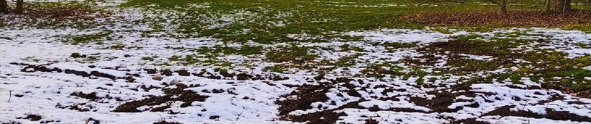
Une belle promenade dans des paysages variés mais à faire de préférence par temps pas trop humide car les chemins peuvent, comme aujourd'hui, être très, très boueux !