


Pipay Gd Rocher via croix de Monteynard

rolland-a
User
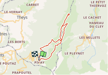

Length
14.4 km

Max alt
1915 m

Uphill gradient
543 m
Km-Effort
22 km

Min alt
1496 m

Downhill gradient
550 m
Boucle
Yes
Creation date :
2022-01-10 17:49:29.517
Updated on :
2022-01-10 18:08:19.586
--
Difficulty : Difficult

FREE GPS app for hiking
 SityTrail
IGN / Geographical institutes
SityTrail Plus
The world is yours!
About
Trail Snowshoes of 14.4 km to be discovered at Auvergne-Rhône-Alpes, Isère, Theys. This trail is proposed by rolland-a.
Positioning
Country:
France
Region :
Auvergne-Rhône-Alpes
Department/Province :
Isère
Municipality :
Theys
Location:
Unknown
Start:(Dec)
Start:(UTM)
265851 ; 5016883 (32T) N.
Comments