


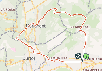
DUrtol Puy Charmont Bancillon

Papou63patrick
User

Length
10.9 km

Max alt
626 m

Uphill gradient
361 m
Km-Effort
15.7 km

Min alt
392 m

Downhill gradient
360 m
Boucle
Yes
Creation date :
2022-01-10 19:30:38.788
Updated on :
2022-01-10 19:32:11.442
3h34
Difficulty : Difficult

FREE GPS app for hiking
 SityTrail
IGN / Geographical institutes
SityTrail Plus
The world is yours!
About
Trail Walking of 10.9 km to be discovered at Auvergne-Rhône-Alpes, Puy-de-Dôme, Clermont-Ferrand. This trail is proposed by Papou63patrick.
Positioning
Country:
France
Region :
Auvergne-Rhône-Alpes
Department/Province :
Puy-de-Dôme
Municipality :
Clermont-Ferrand
Location:
Unknown
Start:(Dec)
Start:(UTM)
506567 ; 5071091 (31T) N.
Comments