


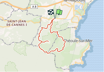
TREMBLANT MONGES CADIERE RETOUR

clintest
User

Length
14.2 km

Max alt
364 m

Uphill gradient
556 m
Km-Effort
22 km

Min alt
15 m

Downhill gradient
555 m
Boucle
Yes
Creation date :
2022-01-11 10:01:12.613
Updated on :
2022-01-11 10:01:47.317
4h55
Difficulty : Medium

FREE GPS app for hiking
 SityTrail
IGN / Geographical institutes
SityTrail Plus
The world is yours!
About
Trail On foot of 14.2 km to be discovered at Provence-Alpes-Côte d'Azur, Maritime Alps, Mandelieu-la-Napoule. This trail is proposed by clintest.
Positioning
Country:
France
Region :
Provence-Alpes-Côte d'Azur
Department/Province :
Maritime Alps
Municipality :
Mandelieu-la-Napoule
Location:
Unknown
Start:(Dec)
Start:(UTM)
331337 ; 4821230 (32T) N.
Comments